 |
||

|
Featured Research Project (September - October 2001)
Land-Cover Change in the North Central Region: Hot Spots of Landscape Change Project
Dr. Daniel G. Brown, Associate Professor Project Overview
Human modification of the landscape, through land use change and land cover change, has significant and long-lasting impacts on ecosystem processes and biodiversity. Although satellite remote sensing has provided an unprecedented ability to monitor landscape changes, comparing contemporary land cover patterns observed from satellite with historical patterns derived from aerial photographs, regional inventories, and other sources pose significant challenges for understanding the human impact on the environment.
Project Goal & Objectives
The goal of our work is to generate land-cover change data for the seven-state North Central Region in support of the Hotspots of Change Project. The specific objectives are: Methods
We propose implementing two approaches to merging disparate spatial datasets for change analysis: 1) developing a time-two (T2) satellite image classification in a way that closely approximates the time-one (T1) photo-interpreted classifications; and 2) use of a third independent data set that is collected consistently for aggregate regions across the two dates to constrain and improve the comparability of the classifications. We will implement the first by interpreting a sample of NAPP aerial photographs from the year 2000 following LUDA protocols. The interpreted land-cover maps (i.e., "simulated LUDA") will be used for calibrating the AVHRR image classification to LUDA and validating the comparison of the two. We will implement the second by using NRI land-cover statistical data to, first, determine the relationship between aggregate NRI and aggregated LUDA land-cover proportions and, second, develop expected proportions in each land-cover category for the AVHRR 2000 image classification. We will use an independent sample of NAPP interpreted photos and NRI statistical data for validation. We believe these methods will produce the most accurate final 1-km change product possible using these data.
SNRE Staff and Student Researchers
Dan Brown, Ph.D., Kathleen Bergen, Ph.D., Sophie Wang (graduate student)., James Rutherford (undergraduate student)
Other SNRE Projects Associated with the Land Use and Land Cover Change
Developing Land Cover Scenarios in Metropolitan and Non-Metropolitan Michigan, USA:
Modeling Siberian Boreal Forest Land-Cover Change and Carbon Under Changing Economic Paradigms: [NASA/LCLUC] Kathleen Bergen, Dan Brown, Eric Kasischke (U. Maryland), Hank Shugart (U. Virginia)
Biocomplexity-Incubation: Exploring Biocomplexity at the Interface of Social and Ecological Systems: [NSF] Dan Brown, David Allan, Tom Crow, Joan Nassauer, Steve Yaffee
Landscape Level Analysis Linking Urban Sprawl and Aquatic Ecosystems: [USDA Forest Service] Dan Brown, Joan Nassauer
Development and Testing of a Decision Support System For River Restoration: [NSF] David Allan, Gloria Helfand, Joan Nassauer |
|
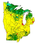 This project addresses those challenges, and supports the needs of the Hot Spots of Landscape Change Project headed by Eric Gustafson in the USFS North Central Research Station, by generating land-cover change data for the seven-state North Central region. The region includes the states of Illinois, Indiana, Iowa, Michigan, Minnesota, Missouri and Wisconsin. The basic objective is to use a national land-cover map from 1980 (USGS LUDA) and AVHRR satellite imagery from 2000
  and identify areas within which substantial changes have occurred. We are developing a method to make these datasets comparable and will perform a validation of the results through use of a sample of 85 interpreted aerial photographs and land cover inventory data collected as part of the Natural Resources Inventory (NRI). The methods developed here have the potential to be applied over longer time scales (aerial photographs in the US are available beginning in the 1930s) and can improve our ability to map land cover over large areas.
Home | Site Map | Search | © 2009 Ecosystem Management Initiative. Terms of Use