
Image

 back to all news
Massive amounts of data have been collected from the Great Lakes basin, but until recently, no effort had organized this information and made it easily accessible. In addition, there wasn’t a tool that allowed researchers and managers to visualize and summarize habitat conditions for the entire basin, especially across the US and Canadian border.
Catherine Riseng, Assistant Research Scientist at U-M’s School of Natural Resources and Environment (SNRE), notes that this gap in data synthesis and sharing had been long recognized.
“There was nothing out there linking the wide array geospatial information, with data from all of the ongoing research and monitoring efforts,” says Riseng. In 2012, she and her team decided to tackle the problem.
With a grant from the Great Lakes Fishery Trust and support from the Michigan Department of Natural Resources (DNR), Riseng worked with an interdisciplinary team to develop the Great Lakes Aquatic Habitat Framework (GLAHF), the first publically-available database that includes harmonized habitat data and a classification of fish habitats across the entire Great Lakes basin.
“The GLAHF allows people to see all the available data and use it to better guide restoration or management planning and monitoring,” Riseng explains.
What makes the project especially unique is that it reaches across the binational border. Over the course of the four-year project, representatives from both Canadian and US agencies and universities served as part of an advisory team, offering their perspectives through meetings and workshops. “We worked hard to incorporate input from agencies managing both sides of the border to ensure that GLAHF is relevant binationally,” says Riseng.
In technical terms, GLAHF is defined as a “publically accessible, binational collection of authoritative, fundamental geospatial data, a raster geodatabase to manage aquatic ecosystem data, and an aquatic ecological classification system.”
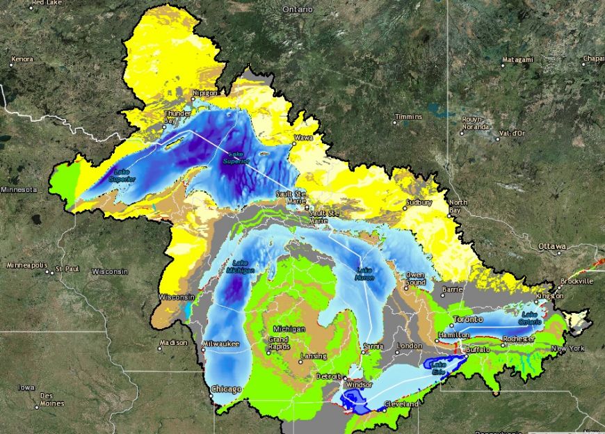
While the layperson may struggle to comprehend the full implications of the system, the web-based GLAHF Explorer provides a visualization that is as intriguing as it is instructive. Riseng’s team worked with developers for over a year to create the ecosystem management tool, employing “design thinking” methods to maximize the usability of the interface. With the entire Great Lakes basin mapped on a multi-layered grid, researchers and managers can overlay and examine data such as temperature, ice-cover duration, water depth, aquatic vegetation, and wave height for every location in the basin. Explorer also contains layers for shoreline classification, wetlands, and walleye populations, among others.
“The ability to quantify and compare hydrologic and landscape-scale data for watersheds that stretch across multiple jurisdictions is of particular importance,” says Riseng, “This provides managers and researchers with a needed tool to identify and quantify changing environmental conditions and indicators across the US and Canada.”
The GLAHF spatial framework, database, and aquatic habitat classification are now housed at the University of Michigan. Riseng notes that the Michigan DNR Institute for Fisheries Research supports one part-time person to update and maintain the data, but she is seeking additional funding to ensure sustainability of GLAHF forward. “More funding will allow us to add more data and develop additional tools,” she says, “and enable us to increase GLAHF’s utility for addressing management and research needs in the future.”
The below photos demonstrate a few of the viewing options in Explorer, such as spawning locations, substrate, bedrock, ice duration, and water depth. The title photo shows bedrock and ice depth.


